 |
||
Global Flight Paths by Michael Markieta
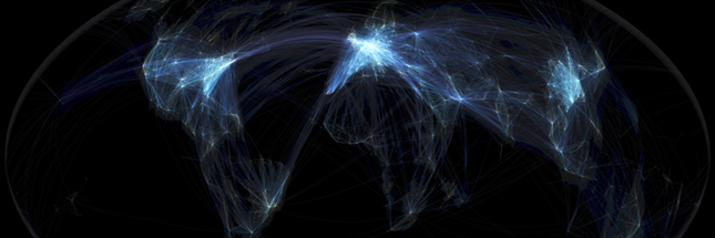
Infographics are sexy. They are such a beautiful way of displaying large amounts of data in an understandable fashion. This project by Michael Markieta was spotted on the BBC News Picture Gallery – always a good source for nice-looking images.
Michael used open source data – available at openflights.org – to help produce these fantastic visualisations. The data shows the flight paths of 58,288 flights in 2011 and is a cracking example of what can be done with open-source, big data. The artist points out that some interesting patterns of settlement and urbanisation can be seen in the infographic. For example, "the United States has flights arriving and departing all over the country, where as Canada has most flights located along the southern Canada-USA border (with a few continental flights travelling into the North)."
A more in depth analysis can be found on Michael's blog, along with the tools and skills necessary to build a map of your own. What's brilliant about all of this is that it is (mostly) open source software!

