High-Resolution Sonar for Shallow Water Imaging
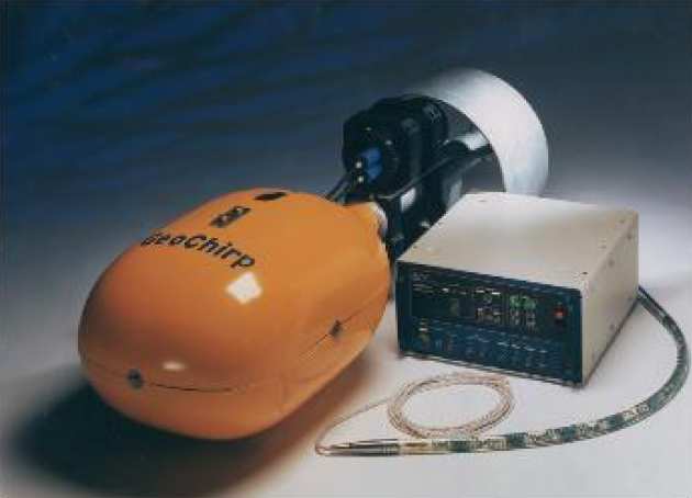 Geoacoustics geochirp sub-bottom profiler
As a result of a successful bid to the Higher Education Funding Councils for Wales and England (Joint Research Equipment Initiative), we have been funded to acquire a suite of geophysical equipment designed for surveying the detailed surface and sub-surface structure in shallow water. The principal components will be two high- resolution multibeam sonars, a sidescan sonar, ´CHIRP´ sediment profiler and boomer seismic system, shared amoungst our consortium (Cardiff, Imperial College, Southampton, Durham, Leeds).
Equipment purchased
Reson Seabat 8101 , Seabat 8160 and TSS POS/MV together with ancillary survey equipment. The two sonars provide highly acurate (1.5 degree beam widths), multibeam bathymetry data, the former operating at 240 kHz (giving a slant range of up to 300 m) and the latter 50 kHz (giving a slant range of up to 3000 m). Both systems have the ability to collect backscatter data. The POS MV provides highly accurate position, motion and heading information, complementing the capabilities of the SeaBat multibeam systems.
Geoacoustics high resolution, portable dual frequency sidescan sonar (100/400 kHz) and sub-bottom profiler (2-12 kHz) system. This equipment can collect digital seabed acoustic backscatter (sidescan) and vertical acoustic impedance (sub-bottom profiler) data in fresh and saline water. The sidescan sonar can switch from wide-swath reconnaissance work (swath width of a few hundred m) to narrow-swath high-resolution imaging (swath width of <100 m). The sub-bottom profiler gives a vertical resolution which will typically be 20 cm, and depth of penetration 20-30 m in medium grained sediments. It has a selectable operational bandwidth of the profiler to give maximum flexibility between resolution and penetration. The equipment works in a wide range of water depths, from about 10m to 500 m. In order to achieve this depth range without compromising data quality, the system can be deep towed within a few metres above the seabed. The sidescan and profiler can operate either individually or simultaneously without degrading each other’s performance. The entire system can be installed and operated on a variety of research vessels or small vessels of opportunity by a small team of 2-3 people in moderate sea and weather conditions and at speeds of 2-5 knots. Surface electronics and computing hardware and software provide comprehensive display, digital recording and replay facilities.
Imperial College Publications
McGonigle, . and J. S. Collier (2014). Interlinking backscatter, grain size and benthic community structure. Estuarine, Coastal and Shelf Science 147: 123-136. PDF
Collier JS, Humber SR, (2011). Fringing reefs of the Seychelles inner granitic islands, Western Indian Ocean, Seafloor Geomorphology As Benthic Habitat, Editors: Harris, Baker, Amsterdam, Pages: 339-347 Link
Brown, C. J. and J. S. Collier (2008). Mapping benthic habitat in regions of gradational substrata: An automated approach utilising geophysical, geological, and biological relationships. Estuarine, Coastal and Shelf Science 78: 203-214. PDF
Collier, J. S. and S. R. Humber (2007). Time-lapse side-scan sonar imaging of bleached coral reefs: A case study from the Seychelles. Remote Sensing of Environment 108: 339-356. PDF
Gupta, S., J. S. Collier, A. Palmer-Felgate and G. Potter (2007). Catastrophic flooding origin of shelf valley systems in the English Channel. Nature 448(7151): 342-345. PDF
Collier, J. S., S. Gupta, G. Potter and A. Palmer-Felgate (2006). Using bathymetry to identify basin inversion structures on the English Channel shelf. Geology 34: 1001-1004. PDF
Collier, J. S. and C. J. Brown (2005). Correlation of sidescan backscatter with grain size distribution of surficial seabed sediments. Marine Geology 214: 431-449. PDF