Challenging long-held assumptions about what controls the largest earthquakes
by Gege Li
/prod01/channel_4/imperial-news/media/news-images/3000X2000-main-article-images/earthquake_potential%5B2%5D.jpg)
When it comes to assessing the potential for very large earthquakes, one of the strongest clues may lie in how strongly tectonic plates are locked together, research has revealed.
Subduction zones not only produce the biggest and most powerful earthquakes on Earth, but they are also home to millions of people around the world – so understanding what controls their behaviour is vitally important for assessing hazard and improving preparedness. Dr Rebecca Bell Associate Professor in Tectonics, Department of Earth Science & Engineering, Imperial
The study, involving Imperial’s Department of Earth Science and Engineering (ESE), challenges a widely held hypothesis in earthquake science that the roughness of the interface between two converging tectonic plates – the region where the plates collide is called a subduction zone – is a major control on the maximum size of earthquakes.
Instead, the team discovered that how tightly coupled the plates are is much more closely associated with the potential for earthquakes.
“Subduction zones not only produce the biggest and most powerful earthquakes on Earth, but they are also home to millions of people around the world – so understanding what controls their behaviour is vitally important for assessing hazard and improving preparedness,” said study co-author Dr Rebecca Bell, Associate Professor in Tectonics in ESE.
“Our work, which looked at global datasets, has shown that this assumed relationship between roughness and earthquake size doesn’t hold up when tested against global data, rather than just one region.”
Looking at the geometry of faults
When a heavier, denser tectonic plate sinks beneath a lighter plate at a subduction zone, the two plates can become locked together, building up pressure that in some cases eventually releases as massive quakes of magnitude 8.0 or higher.
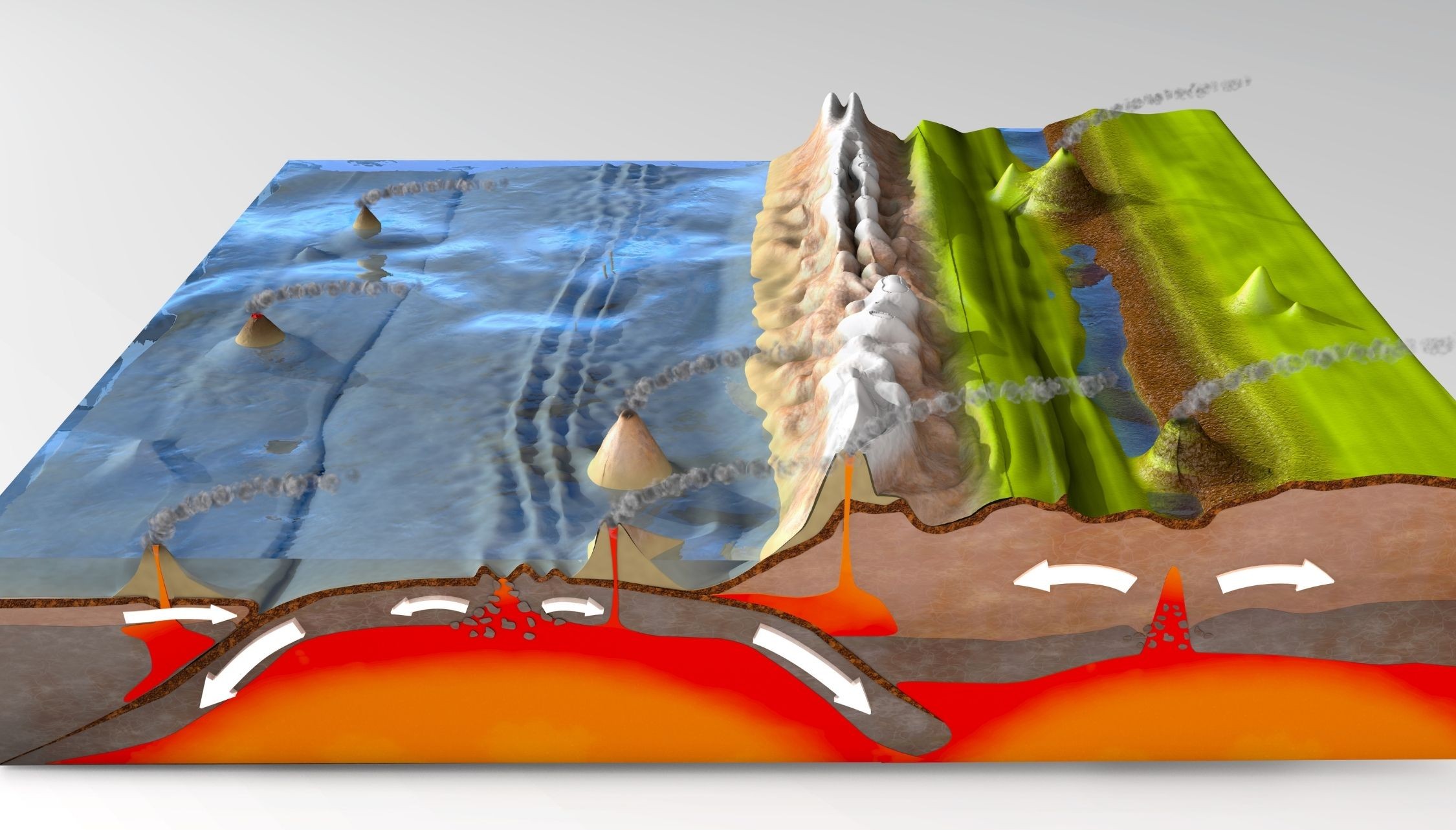
For decades, geoscientists have debated how the topography of the subducting seafloor – in the form of seamounts, ridges and other features – influences seismic behaviour. One leading hypothesis is that smooth interfaces allow for massive, continuous ruptures, while rough interfaces act as barriers, breaking and stopping earthquake rupture and limiting earthquake size.
“We wanted to test this theory using direct observations of the geometry of the fault itself, instead of relying on indirect clues, like gravity data and the depth of the seafloor, that don’t give the most accurate picture of what is really going on,” said Dr Bell.
Roughness fails to predict earthquake size
The team compiled and analysed 35 seismic reflection cross-sections, that provide images below the seabed down to the plate boundary, from 15 subduction margins worldwide, including Cascadia, Japan, Chile, Sumatra and the Hikurangi margin off New Zealand.
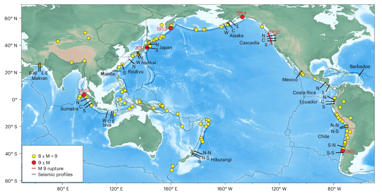
Unlike previous studies, this study – published in Nature Geoscience – used seismic imaging data to make the most comprehensive comparison to date based on direct, high-resolution observations of plate boundary geometry.
The team measured roughness in three ways, at scales from one to 10 kilometres, and compared the results against both the maximum earthquake magnitude and how locked or ‘stuck’ the plates are (called interface coupling) at each margin.
In contrast to the long-held theory, they found no clear link between plate-interface roughness at the one-to-ten-kilometre scales investigated and maximum earthquake magnitude. Magnitude 8.0 or greater earthquakes occurred on margins ranging from some of the smoothest to the roughest studied – including the 1960 Valdivia earthquake in Chile, the largest ever recorded at magnitude 9.6, which struck one of the roughest segments.
“The data show that both rough and smooth subduction margins can host magnitude 8.0 or greater earthquakes, so roughness alone simply can’t tell us which margins have the potential to produce great earthquakes,” said co-author Dr Alexander Whittaker, Reader in Landscape Dynamics in ESE.
Locked plates point to bigger quakes
What the study did uncover, however, was a strong link between maximum earthquake magnitude and interface coupling: where the plates are strongly locked together, larger earthquakes tend to have occurred. This is a key indicator that ground-movement measurements of coupling may be a more useful indicator of earthquake potential than fault roughness.
Previous studies have often used seabed topography or gravity data as proxies for the roughness of the plate interface, but the study suggests this approach is flawed – seafloor features are often scraped off or smoothed by sediments before reaching the zone where earthquakes are generated.
“Instead of measuring roughness to infer the earthquake potential at a margin, we should focus our resources on expanding networks of sensors on the seafloor to measure coupling more precisely,” said Dr Whittaker. “That could substantially improve our assessment of earthquake potential.”
This research grew out of co-author Angela Knowlson’s thesis when she was an undergraduate student in the Department of Earth Science and Engineering at Imperial, where she calculated and compared roughness indicators at subduction zones. Her work formed the basis for this study’s analysis – highlighting how student research can lead to real discoveries on a global scale.
Rethinking earthquake hazard models
This work is a prime example of how fundamental research in Earth Science and Engineering can ultimately help communities prepare... By improving our understanding of what controls earthquake size, we can move towards more accurate hazard assessments for the millions of people living near subduction zones. Dr Rebecca Bell Associate Professor in Tectonics, Department of Earth Science & Engineering, Imperial
While the dataset is the best available sample of direct observations of the plate boundary, with the global subduction system exceeding 50,000 kilometres in length, future work will need to capture 3D images of the fault surface, as well as combine ground-movement and geological data.
“This work is a prime example of how fundamental research in Earth Science and Engineering can ultimately help communities prepare, by improving the evidence that underpins seismic hazard assessments, building codes and emergency planning,” added Dr Bell.
“By improving our understanding of what controls earthquake size, we can move towards more accurate hazard assessments for the millions of people living near subduction zones.”
Article text (excluding photos or graphics) © Imperial College London.
Photos and graphics subject to third party copyright used with permission or © Imperial College London.
Article people, mentions and related links
Gege Li
Faculty of Engineering