Mountain range is being created and destroyed by earthquakes
by Colin Smith
Scientists have shown that earthquakes, not an ancient wetter climate as previously thought, are eroding the mountains in Peru.
A team of geologists including an Imperial researcher have for the past several years been studying cobbles, which are stones that have been rounded as they bounce downstream, in the tributary system that feeds into the Pisco River in the Western Andes Mountains of Peru. Measuring the amount of a rare radioactive isotope Beryllium-10 in the cobbles has enabled them to piece together the last 16,000 years to find the dominant cause of landslides in the area.
Our study is helping us to see that the force that has created the Andes - where one part of the Earth’s crust pushes another massive fragment skywards - is also destroying the Andes through earthquakes.
– Dr Dylan Rood
Department of Earth Science and Engineering
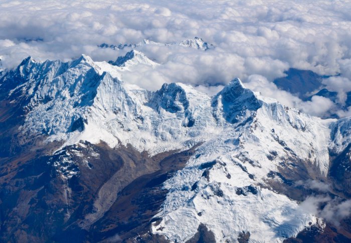
The Andes are the longest continuous and second highest continental mountain range on Earth. They were first formed millions of years ago when a part of the Earth’s crust called the Nazca plate slid under the South American plate, pushing the crust upwards to form the mountains. This process is still occurring and continues to cause some of the largest earthquakes in the world along the western edge of the continent, part of which is known as the “ring of fire”.
More than 16,000 years ago the Western Andes Mountains of Peru was much wetter than it is today. Scientists have debated whether this ancient wetter climate, which likely caused large-scale flash floods, or earthquakes, created by the Earth’s shifting crust, were the dominant cause of erosion in the region.
The team collected samples from an ancient pile of rocks that was deposited by the Pisco River during a period when the climate was wetter. About 16,000 years ago, the river flooded a former valley and left the cobbles behind. Today’s river has cut through this rock pile, revealing these ancient deposits again for the team to collect. They also gathered cobbles from the bottom of the river that was deposited more recently.
By analysing the cobbles to determine the presence of Beryllium-10, the team have found that earthquakes have been the major source of landslides in the region for thousands of years, even when a much wetter ancient climate was taken into account. This finding provides insights into the geological processes that help to shape the region today.
The study was carried out by researchers from the University of Syracuse, the University of Vermont and Imperial College London.
Dr Dylan Rood, from the Department of Earth Science and Engineering at Imperial College London, says: “The now very dry environment of the Andes Mountain range provides us with a really rich source of geological information that has been preserved for thousands of years. Our study is helping us to see that the force that has created the Andes - where one part of the Earth’s crust pushes another massive fragment skywards - is also destroying the Andes through earthquakes. Even when we account for a much wetter ancient environment, the evidence still points to earthquakes being the dominant form of erosion in the region for a very long time.”
The team compared ancient and newer river cobbles to determine the source of the erosion by measuring the amount of the Beryllium-10 contained in them. Beryllium-10 is created when cosmic rays from space hit minerals, such as quartz, in cobbles, which splits the oxygen inside the cobble, leaving Beryllium-10. The scientists liken this process to the rocks getting sunburn, because the longer the cobble remains on the surface of Earth, the more exposed it is to cosmic rays, and the more Beryllium-10 is created inside the rock.
The scientists knew that processes that results in shallow erosion, including that which is caused by water, generates cobbles that are exposed on the surface for a relatively long while, which means that more Beryllium-10 is created. Erosion from landslides is relatively deep and quick in geological terms, exposing cobbles on the surface for a relatively shorter time, meaning that they contain less Beryllium-10.
The team used an accelerator mass spectrometer located in Scotland to sift through billions of atoms in the cobbles to find Beryllium-10. They discovered small but similar amounts of Beryllium-10 in samples from both the ancient and modern cobbles, where one in a million billion atoms was Beryllium-10. This indicated to the researchers that certain cobbles were exposed on the surface for a relatively short period, meaning that erosions from landslides were the source of the cobbles. Because the landslides were happening similarly in both the wet and dry climate periods, earthquakes were likely causing these landslides, say the team.
The team’s research suggests that changes in climate over thousands of years had a relatively minor effect on erosion processes in earthquake prone regions like the Andes Mountians. The next step will see the researchers measuring how other rivers and mountain chains have responded to past climate changes around the world. For a warming globe, new insights into how sensitive these Earth systems were to changes in the past will allow us to prepare for the future.
The story was published in the journal Nature Geoscience.
Article text (excluding photos or graphics) © Imperial College London.
Photos and graphics subject to third party copyright used with permission or © Imperial College London.
Reporter
Colin Smith
Communications and Public Affairs