The second phase of our work will provide us with many opportunities to improve our survey response numbers through the production of an extra 5,000 field packs, increase our project beneficiary numbers, as well as allow us to target selected areas for more detailed data collection and laboratory analysis. This will also be used to supplement our existing database.
In agreement with the project steering committee, and through our analysis of Phase 1 data using interpolation in GIS to produce prediction plots, we have been able to identify areas of the country to be targeted for investigation in Phases 2 and 3. Our strategy will be to target areas of low Phase 1 survey response density for extra community involvement, making use of the extra 5,000 field packs. In addition to this, we will target areas of the country that represent areas of high, low, and average reported earthworm numbers.
Phase 2
The rationale for the way in which the Phase 2 research agenda would be identified was always intended to be results-led from analysis of the Phase 1 public survey data. To this end, analysis of the data was done which revealed that there were areas of the country where numbers of survey results was low, leading to a lack of confidence in results obtained from these areas. A sophisticated set of GIS (Graphical Information System) algorithms were developed and applied to the data, which provided levels of confidence in the data, such that areas of a high enough survey density could be thresholded from areas of low survey density.
General objectives for Phase 2 were to:
- test hypotheses arising from Phase 1 data anlysis via targeted fieldwork;
- increase the quality, quantity and scientific value of data collected;
- allow us to communicate interesting findings to the community;
- deliver benefits to national survey by focusing on areas of low participation.
More specifically to:
- assess the reliablity of the prediction plots created from analysis of Phase 1 data;
- determine if there is sufficient data driving the spatial patterns;
- select patterns for Earthworm Total numbers to investigate decline in soil quality - “smoking gun”.
Research Questions
In order to achieve the above, a series of research questions were identified:
- Are the patterns of cold spots and hot spots of earthworm density reliable and recoverable by subsequent sampling?
- What soil properties are correlated with these patterns?
- Are cold spots of earthworm density associated with urbanisation and/or agricultural intensification?
- Conversely, are hot spots of earthworm density in particularly undisturbed and lightly farmed areas?
Sites for Phase 2 work were selected based on GIS analysis of the survey density data received from members of the public participating in the Phase 1 national survey. This data was then combined with publicly available data obtained from the Office for National Statistics to identify areas where survey density was below a useful level and that coincided with areas of the country that register low on the national deprivation index. The following set of maps demonstrate this methodology.
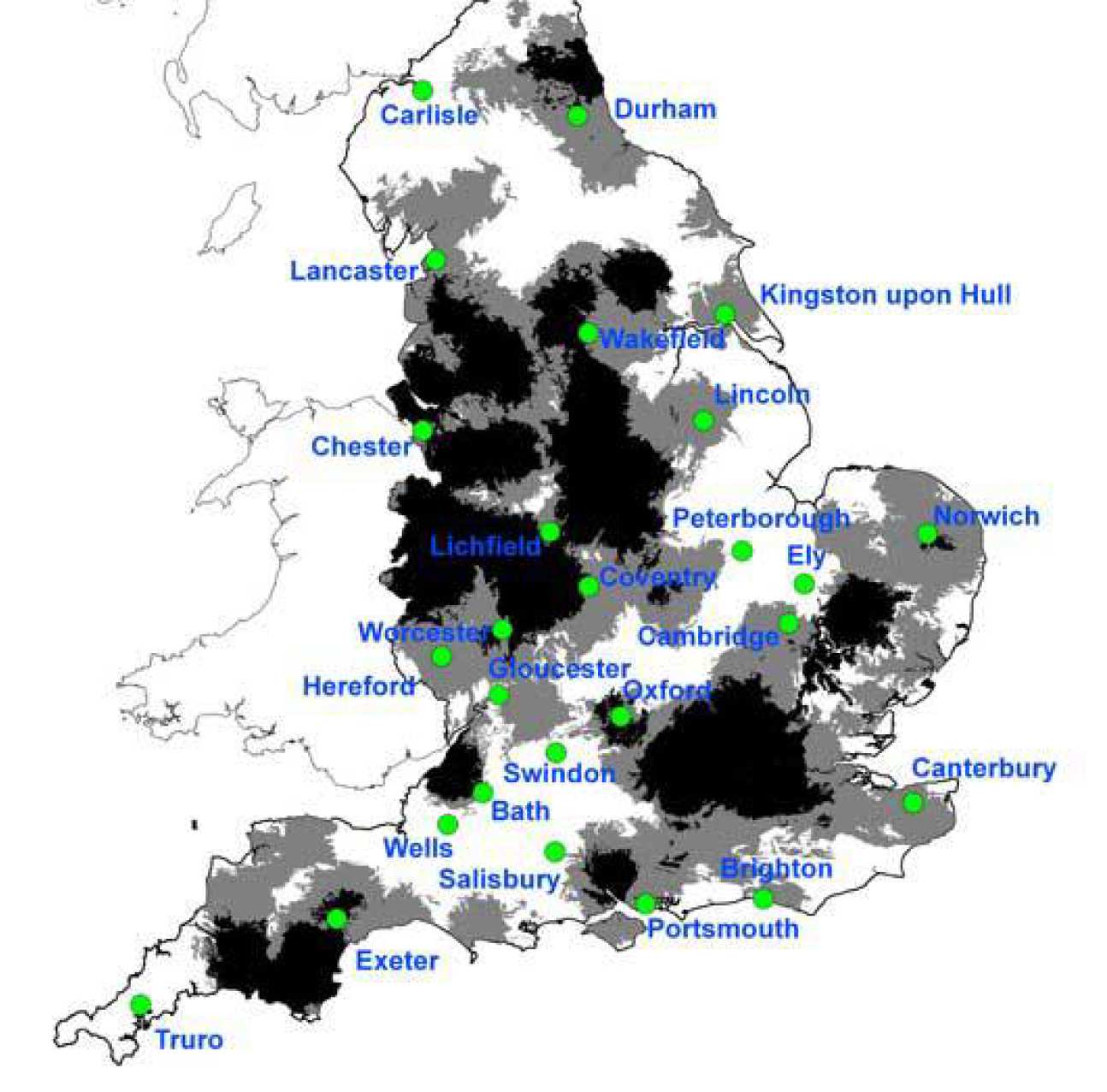
A big “Thank you” to all our many citizen scientists who have submitted the results of their Soil & Earthworm Surveys. The results have helped us to understand more about soil properties and the distribution of earthworms across the country. The map below shows the coverage of submitted survey results across England. The black areas of the map show those parts of the country where we have had high numbers of survey submissions. The grey areas have intermediate numbers, and the white areas show parts of the country with no submissions or very low numbers of submissions so far. To improve our research, we need to fill the gaps in the “under-sampled” white areas of the map by getting as many survey returns in these areas as possible. Please help us to turn as much of the map grey or black.
Any new surveys you can do will be extremely useful, even in the black areas, as your findings will help to improve the patterns we have found in the results. What’s more, if you can do surveys in the grey or white areas, that would be particularly valuable. And if you have done the survey in the past but have not yet submitted your results, it’s not too late. So, please dig out those old survey answer sheets, and send us your results.
The best time of year to do the Soil & Earthworm survey is the Spring or Autumn when the soil is moist. So, why not get outside in the next few months to contribute to our scientific research.
But watch out, don’t do the survey if the soil is dry during the Summer because you will find very few earthworms. Find out more about how to take part in the Soil and Earthworm Survey or why not come along to one of our events and meet the scientists who are analysing your results.
To support the OPAL Soil and Earthworm Survey scientists from the OPAL Soil Centre will be attending or helping organise a series of public events. The locations of these events aim to help increase the number of results in areas where not many surveys have been carried out yet. The table below lists some of the up and coming events that we have planned.
If you are interested in having a scientist from the OPAL Soil Centre attend your event to run Soil and Earthworm Surveys or an earthworm identification course then please contact us.
| Date | Event | Location | Organiser |
|---|---|---|---|
| 29-Apr to 1-May' 11 | Fossil Festival | Lyme Regis | West Dorset District Council |
| 13-May' 11 | London Earth Seminar | London | British Geological Survey |
| 31-May' 11 | Nature Festival | Ashcombe, Exmoor | Exmoor National Park |
| 3-4 June' 11 | Scarborough Bioblitz | North Yorkshire | OPAL |
| 25-26 June' 11 | RGS Reunion | Cumbria | RGS |
| 6 July' 11 | School Science Week | Lancaster | Lancaster Girls Grammer School |
| 9 July' 11 | Nature Festival | King's Lynn | Breckland Council |
| 16 July'11 | Family Fun Day | Tonbridge, Kent | |
| 20-21 Aug' 11 | Green Man Festival | Crickhowell, Wales | Glanusk Park |
| 21 Sep' 11 | Get your hands dirty | Haltwhistle, Northumberland | Federation of City Farms and Community Gardens |
| 25 Sep' 11 | Families Nature Day | Thetford, Suffolk | Forgotton Garden |
| 28 Sep' 11 | Naseby Nature Day | Naseby Battlefield | OPAL |
| 1 Oct' 11 | Earthworm Day | Camberley, Surrey | Blackwater Valley Countryside Partnership |
| 9 Oct' 11 | Earthworm ID Course | Ormskirk | West Lancashire Wildlife Trust |
| 26 Nov' 11 | Survey Training & Earthworm ID | Norfolk | Norfolk Master Composters |
| 21 Mar' 12 | Earthworm survey and seminar event – closed | Gloucestershire | Gloucestershire Master Composters |
| 5 Apr' 12 | Earthworm survey and seminar event – closed | Shropshire | Shropshire Master Composters |
| 13 Apr' 12 | Earthworm ID Course– open to public | Blencathra, Lake District | Field Studies Council |
| 21 Apr' 12 | Earthworm ID Course– open to public | Malham Tarn, Yorkshire Dales | Field Studies Council |
| 25 Apr' 12 | Earthworm survey and seminar event – closed | Leicestershire | Master Composters Association & Master Gardeners Association |
| 19 May' 12 | Earthworm survey and seminar event – closed | Buckinghamshire | Buckinghamshire Master Composters |
| 27 May' 12 | Big Nature Day | Natural History Museum, London |
Natural History Museum/ OPAL |
| 30 May' 12 | Earthworm survey and seminar event – closed | Master Composters National HQ, Ryton, Coventry | Master Composters Association & Master Gardeners Association |
| 20 Jun' 12 | Earthworm survey and seminar event – closed | Oxfordshire | Master Composters Association & Master Gardeners Association |
| 8th Dec' 12 | Urban Ecology Dig | Whitechapel Gallery, London | Whitechapel Gallery |