Deformation measurement and geological insight from InSAR for the rural UK
Started: October 2017
Supervisors: Dr. Richard Ghail, Dr. James Lawrence
Funding: Radioactive Waste Management Ltd., EPSRC;
BACKGROUND:
Interferometric Synthetic Aperture Radar (InSAR) is a family of techniques for processing satellite radar imagery in order to measure ground displacements. It can offer significant spatial coverage (orders of 1000km2 constrained only by processing time) and submillimetre precision, thus potentially providing significant advantages (cost, time, coverage and accuracy) over more traditional techniques such as levelling and GPS. DInSAR can potentially provide a complete picture of an areas deformation by effectively allowing every consistent target on the ground (e.g. building, car park, pylon, telephone pole, rock outcrop) to be used as a discrete GPS instrument. Among other uses this allows us to locate faults; characterise the effects of ground engineering (i.e. tunnelling, dewatering); and better understand ongoing geological processes.
Significant limitations exist when applying InSAR to rural areas, as the movement and growth of vegetation precludes measurement of the ground it obscures. To optimise InSAR techniques for rural environments thus requires us to make the most of the consistent targets available, and develop our methods of identifying intermittent consistent behaviour.
Along with ground displacement toward the satellite, raw interferometric data is measures of changes in atmospheric delays; in scattering behaviour of targets, positional errors, apparent topography, and noise. Properly accounting for and modelling these combined effects is thus necessary to recover the ground deformation component we seek. Techniques for isolating these effects all have room for improvement.
RESEARCH AIM:
This project is thus concerned with (as necessary) identifying, developing, testing, and implementing improved software techniques for improvement in the accuracy and amount of data recovered in rural areas. The techniques ultimately developed are hoped to provide a better understanding of the geology driving deformation, and allow a robust method of identifying the surface and basement faults which guide deformation within an area.
Such developments will hopefully aid UK efforts in developing a geological disposal facility for radioactive waste, where robust knowledge and understanding of a site is required. InSAR has the potential to generate geological insight, provide monitoring, and in the near-term optimise the locations of site-characterising boreholes.
DESCRIPTION OF RESEARCH:
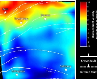
Initial research has focused on comparing existing software approaches, mainly the established PSInSAR and SBAS techniques. Techniques were shown to be highly capable of fault identification in rural areas and revealed the marked contribution of seasonal groundwater in deformation.
In terms of developing techniques, investigation is currently focused on using additional bands of amplitude data to characterise targets in order to better guide deformation analysis. Implementing more realistic (i.e., higher order and more informed) deformation modelling is a distinct priority.

Contact Geotechnics
Geotechnics
Civil and Environmental Engineering
Skempton Building
Imperial College London
South Kensington Campus
London, SW7 2AZ
Telephone:
+44 (0)20 7594 6077
Email: j.otoole@imperial.ac.uk
Alternatively, you can find a member of Geotechnics staff on the Department of Civil and Environmental Engineering website.
Follow us on Twitter: @GeotechnicsICL
We are located in the Skempton Building (building number 27 on the South Kensington Campus Map). How to find us
