Implementation of wáter management policy at the river basin scale
A case study of the Anglian region, UK
Globaqua - Broads

The Anglian region, and the Broadland Rivers catchment form one of the six selected basins affected by water scarcity (due to either climatic or societal factors) studied under the GLOBAQUA project. Each basin focuses on a specific set of stressors to illustrate different management scenarios, and in the Anglian case their evaluation is to be based on existing data.
The area covers 3200km2 and includes the Broads Executive area which, due to its high density of protected sites, has the equivalent management status to a national park. There is considerable background knowledge and information in this catchment that can be used to undertake a comprehensive study with an active management consortium of stakeholders namely the Broadlands Catchment Partnership (BCP). Other catchment-specific information are summarised below:
- Land use: more than 80% arable - mainly privately owned.
- Population: around 850,000 residents
- Tourism: 7.4 million visitors supporting >6000 jobs, spending £469M in the Broads in 20111
- Agriculture: 8,500 jobs in the wider Broadland area rely on farming
Water within the Anglian RBMD is heavily exploited with water abstracted to meet the needs of its growing population and to maintain the region’s highly productive agricultural industry. The current implementation of the WFD within the Anglian Region is governed by the compliance focused approach that complements the reductionist thinking which dominated water management before the enforcement of the WFD. This creates a conflict between the Directive’s objectives to consider holistic principles for water management and the way the Directive is actually implemented. This puts the overall effectiveness of overall management at a disadvantage as certain measures are often enforced to address individual aspects of the water environment in the assumption that their individual improvements would lead to overall improvements in ecosystem health (provision of important goods and services that contribute to societal welfare). To emphasise the challenges associated with the current implementation of the WFD, the Anglian region case study and the subsequent assessment of the Broadland Rivers Catchment have given insights on the limitations of this approach in achieving the necessary water quality improvements to meet the requirements of the WFD. As seen in both the Anglian region and the Broadland Rivers catchment, WFD status classifications deteriorated rather than improved as shown by the increasing number of water bodies classified as poor and bad status. In addition, elemental changes also show a relative degree of deterioration with some water bodies sharing multiple failures. This further emphasises the need to better understand the system to ensure the development of more integrated solutions. Even though much progress is being undertaken to achieve the WFD’s intended holistic principles, the current implementation is not fully complete in its ability to account for important multiple stressor effects. Indeed, this may be because of the uncertainties in the scientific research, thus pursuing multiple stressor approach to management might not be available or might be a costly and ineffective process. Nonetheless, it is not ideal to disregard the growing concerns regarding multiple stressors especially if current evidence base for management does not always infer actual cause-and-effect for freshwater degradation. Perhaps, a “new” approach focussing on more systemic view towards the implementation of the WFD could be undertaken to improve current freshwater management through determining actual causality by investigating those important multiple stressor effects to prioritise management towards those important elements of the system which in turn optimise overall strategy and avoid unnecessary costs. The outputs from GLOBAQUA should greatly improve the implementation of the WFD and the management of water bodies.
Further information
- Introduction to the Anglian River Basin Management District
- The Water Framework Directive in the Anglian River Basin District
- The Catchment Based Approach
- The relevance of GLOBAQUA
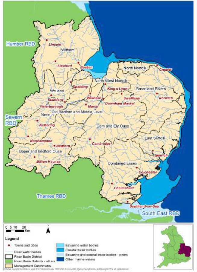
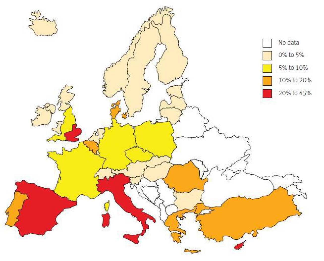
The Anglian River Basin District (RBD) has 7.1 million people living and working in a number of small to medium towns and cities in the area. Land use is predominately rural with more than 50% used for agriculture and horticulture. The RBD is one of the most productive agricultural landscapes in the world and is best known for its cereal crops, producing more than a quarter of England’s wheat and barley. The river basin district is also a major horticultural region cultivating everything from peas and beans to potatoes and carrots, apples, strawberries, salad crops, flowers and shrubs. Farmers also harvest over half of the nation’s sugar beet (Environment Agency 2009b). The altitude of much of the area is below 60 metres and the Fens, an area of artificially drained wetlands, has the largest tract of low, flat land in the UK. The highest ground is in the south-west of the area where the north-eastwards extension of the Chiltern Hills reaches over 200 metres continuing as the East Anglian Heights (Met Office 2014). The Anglian region is the driest throughout the UK, receiving less than 600mm of rain a year, 70% of the national average. The rain that does fall is evenly spread throughout the year but about three quarters evaporates into the atmosphere, especially in the summer. This leads to an annual cycle of reduced river flows and groundwater levels with most summers showing characteristics of drought, and longer periods of drought have a cumulative effect on water supplies and the environment (Environment Agency 2012a). The proportion of rainfall available after evaporation which is exploited for human use is among the highest in Europe, comparable with Mediterranean countries such as Spain and France (see Figure A2). Furthermore, within the region climate change is widely forecast to lead to drier summers and wetter winters, with an overall reduction in rainfall and groundwater levels. Weather will be more extreme, with frequent periods of intense rainfall, causing floods, and more frequent prolonged dry periods and droughts (Environment Agency 2012a). This coupled with the fact that the Anglian region is one of the fastest growing in terms of population within the UK, means that demands for water are likely to significantly increase.
The climatic conditions and predictions for future increase in water demand, along with currently only 18% of water bodies achieving good status makes the Anglian river basin district an ideal case study basin for the GLOBAQUA project. This chapter looks the policies and regulations that influence the water management in the basin.
Within the Anglian RBD the main driver for water management is the EU’s Water Framework Directive (2000/60/EU). For RBDs that are wholly in England, including the Anglian RBD, the Directive was transposed into law through The Water Environment (Water Framework Directive) (England and Wales) Regulations 2003. This states that the statutory body responsible for the implementation of the WFD in English RBDs is the Environment Agency. The Environment Agency (EA) is an executive non-departmental public body, meaning that it is not an integral part of any government department but carries out their work at arm's length from ministers, although ministers are ultimately responsible to Parliament for the activities of the bodies.
One of the first tasks of the EA under the Water Environment Regulation Act was to designate artificial and heavily modified water bodies. These designations are in recognition that some alterations to water bodies have provided valuable social and economic benefits that would be reduced if the modifications were removed. Nearly 70 per cent of surface water bodies in the river basin district are designated as ‘artificial’ or ‘heavily modified’. This is because they may have been created or modified for a particular use such as water supply, flood protection, navigation or urban infrastructure (Environment Agency 2009b).
The EA implemented monitoring programmes for the WFD in 2006 and reported on these to the European Commission in 2007. For each RBD a liaison panel was set up. These panels include representatives of businesses, planning authorities, environmental organisations, consumers, navigation, fishing and recreation bodies and central, regional and local government.
The first river basin management plans
In 2009 the EA published the river basin management plans for river basins in England, including the Anglian RBD. The plans outline the pressures facing the water bodies and the actions that will address them. They also state the percentage of water bodies in each RBD that were judged to be at good status in 2009 and state the percentages that are due to improve by 2015 as a consequence of the actions outlined. The Anglian River Basin Management Plan (RBMP) stated that 18% of water bodies were at least good ecological status/potential in 2009 and that 65% of groundwater bodies were at good quantitative status. The main pressures effecting surface water bodies in the Anglian region were identified as point source discharges from water industry sewage works, diffuse source pollution from agriculture, abstraction and a range of reasons due to physical modifications, including flood protection and land drainage. The river basin management plan states that as a result of the complexities of pressures affecting surface waters the reason for failures in surface water status is often unknown. As a result the EA proposed a campaign of investigations. For groundwater quality, the main reasons for poor status were identified as high or rising nitrate concentrations, with some failures for pesticides and other chemicals. Abstraction of water, mainly for drinking water, at rates that exceed rates of aquifers recharge was identified as the reason for failure in groundwater quantity status. The Anglian RBMP outlines the actions by individual sectors that were identified as contributing to improvements of water status in the basin. For the agricultural sector, which accounts for more than half of the land use in the RBMD, this includes a combination of incentive, advisory and regulatory measures, e.g. the establishment and enforcement of Nitrate Vulnerable Zones (NVZs), the pesticide statutory code of practice, catchment sensitive farming schemes and incentives for farmers to build storage reservoirs to support summer irrigation. Additionally, a demonstration catchment was set up to in the RBD in order to test and look at the effect of agricultural diffuse pollution control measures. The EA was identified by the RBMP as taking a lead role in the implementation of the WFD. Actions identified in the plan include running local pollution campaigns, working to restore sustainable abstraction and removal of unnecessary barriers to fish migration. Additionally, local and regional governments will have a major role in implementing the RBMP. Key actions required from this sector include working with the Royal Town Planning Institute to produce guidance for planning authorities in support of the RBMP, taking action to reduce the physical impact of urban developments in artificial or heavily modified waters and implementing surface water management plans to increase resilience to surface flooding and ensure water is considered on a catchment basis. The water industry is identified as a major partner in the management and protection of the water environment. Improvement of continuous and intermittent sewage effluent discharges, and of water resources management will be carried out as part of the ongoing water industry asset management programme. Other sectors identified as having a role in delivering the WFD in the Anglian region include urban transport, which should apply the pesticide statutory code of practice, investigate emissions from sites and reduce physical impacts of urban development. Industry including business service providers, retail and health sectors will participate in pollution prevention campaigns and in investigations were appropriate. As the Anglian coast is an important area for navigation the need to ensure waters remain navigable whilst at the same time water quality is protected and improved was identified by the RBMP. Actions from this sector include implementing a ban on tributyltin and the development of a dredging and disposal framework. Additionally, through its role engaging communities and individuals the angling sector was identified as a having a large role to play in delivering on the ground improvements. This will be done through projects such as the Anglian River Sea Trout Project which will identify barriers to fish migration and the Norfolk Non Native Forum which established a network of surveillance and eradications officers. As a result of the actions identified in the RBMP it was predicted that in 2015 16% of surface water bodies will show an improvement for 1 or more element. However, this will only equate to an improvement in ecological status in 1% of water bodies (Environment Agency 2009b).
After the publication of the RBMPs the WWF-UK and the Angling Trust applied to the High Court for a judicial review of the RBMPs. They stated this action was prompted by the lack of ambition in the targets to improve water bodies, the reliance on the extension of timescales for improvements and a continued top-down approach to water management, which were all in conflict with the Directive and transposed regulations (Ends Report 2010). In response to the application for judicial review, on 22 March 2011, Richard Benyon, Parliamentary Under Secretary Minister for the Natural Environment and Fisheries, made a statement committing to a package of new measures for the implementation of the WFD (Benyon 2011). This announcement made a commitment to a catchment based approach to sharing information, working together, coordinating action and collaborating to achieve improvements to aquatic ecosystems (Environment Agency 2012b). This recognised the inseparable nature of land and water and the need to manage both in a more integrated manner. It also recognised the need to do more at a local level in order to achieve the WFD‘s objectives (Benyon 2012). This announcement was welcomed by the WWF-UK and The Angling Trust who withdrew their legal action against the Government (WWF 2011). In April 2012 ten pilot schemes based on the catchment approach hosted by the Environment Agency were set up. A further 15 pilots hosted by external organisations were established in January 2012 (Environment Agency 2012d). An independent evaluation of the pilots was run until January 2013 with the findings published in May 2013 (Cascade Consulting 2013). Within the Anglian RBD there are three catchment partnerships that were used as pilot to test the catchment based approach.
In 2013 the Environment Agency launched the ‘River Basin Districts: Challenges and Choices consultation’. The document for the Anglian RBD provides an overview of the investigations into pressures on the water environment that were conducting during the first river basin planning cycle, summarises the main pressures identified in the river basin and asks the public for their thoughts on the significant issues limiting the benefits society obtains from the water environment (Environment Agency 2013a). This will then be used to inform the creation of the second RBMP in the Anglian RBD. A summary of the main sectors identified as contributing to issues preventing the Anglian RBD reaching good status was also provided (Table ).
Table A1. Main sectors identified as contributing to issues preventing the Anglian RBD reaching good status was also provided(adapted from Environment Agency, 2013). 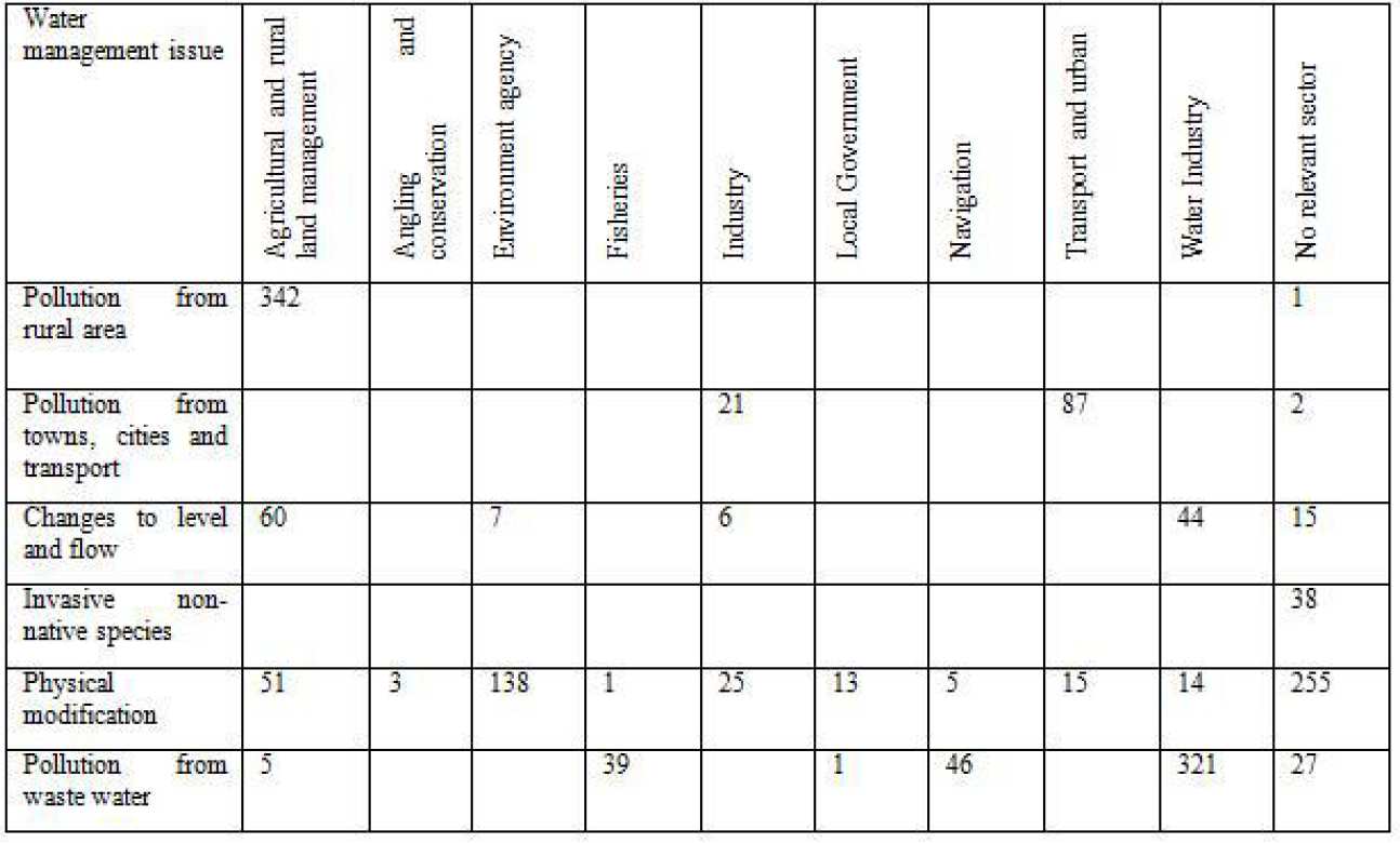
Six main pressures were identified as affecting the RBD. These include changes to the natural flow and level of water. The document outlines current approaches to managing this, which includes investigations into areas where over abstraction may be harming the environment. These investigations were also carried out as requirements under the European Habitats & Wild Birds Directive, Sites of Special Scientific Interest and, Biodiversity Action Plans (BAP) designations. The document states that along with demand management changes to abstraction licenses may also be necessary in the future. The impact of physical modification was also identified as one of the 6 main pressures within the RBD, stating that over 70% of rivers and 77% of lakes in the region have been significantly modified. The current approach during the 1st river basin planning cycle was to identify where physical modifications are limiting ecology and then identified improvements that need to be made to habitats. However, due to the extent and impact of physical modifications across the river basin district, the challenges and choices document identifies that it will take significant investment to achieve all of the improvements required. Therefore, additional actions in the 2nd planning cycle include developing strategies for new flood defences to have reduced impact along with considering new flood storage areas and wetlands, refining dredging programmes and continuing to remove redundant structures and implementing restoration work. Pollution from waste water is also a significant pressure in the district with nutrients (phosphate and nitrates), ammonia, organic matter and metals in waste water the main causes of pollution. Currently this issue is addressed through water companies’ investment programmes which prioritise the most significant sources of pollution and implements solutions for reduction. Future priorities will focus on the reduction of nutrient pollution from phosphorus which will be achieved by through planning and regulating water companies to carry out improvements to their sewage works. Urban areas and transport were also identified as main causes of pollution, with run off containing sediment, chemicals, heavy metals, pesticides and bacteria. The document states that this is currently addressed by influencing new developments to make sure surface water is managed to reduce pollution. However, with significant growth in the towns and cities across the RBD planned more will need to be done to address this and so further information and data, along with increase education of the public and industry has been identified as being required. Pollution from rural areas is also a threat to the WFD’s objectives in the Anglian RBD, with agriculture and private sewage systems the main sources. Current approaches include stewardship schemes and cross compliance through the Common Agricultural Policy, along with Nitrate Vulnerable Zones. However, future education is needed to embed the catchment approach and to improve farming practices. Finally, invasive non-native species were identified as a main pressure on the water environment in the Anglian RBD., stating that 1% of non-native species that escape into the wild can have significant ecological and financial impacts. This is currently being tackled by a regional steering group and action plan. However, legislation is also being used with The Import of Live Fish Act, which requires licences to sell and own non-native fish species and a ban on the sale of five of the most invasive plant species coming into force in 2014.
The consultation document also provides an overview of the significant water management challenges for each catchment of the RBD. The Challenges and Choices consultation was closed on the 22 December 2013 and a summary of the responses provided. The responses will be used to create drafts of the 2nd RBMPs, these will be open for consultation for six months with the final RBMPs due to be published in December 2015.
Table A2. Protected areas in the Anglian RBD (from Environment Agency, 2009b).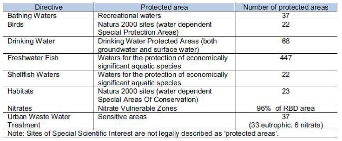
The Water Framework Directive specifies that areas requiring special protection under other EC Directives and waters used for the abstraction of drinking water have their own objectives and standards. Article 4 of the Water Framework Directive requires Member States to achieve compliance with the standards and objectives set for each protected area by 22 December 2015, unless otherwise specified in the Community legislation under which the protected area was established.
Within the Anglian RBMD there are a number of protected areas (see Table A2). These include 22 water dependent sites protected under the Birds Directive and 23 sites protected under the Habitats Directives (Environment Agency 2009a). This reflects the RBD containing Britain’s largest protected wetland and sites of international importance for conservation.
Over 96% of the RBD is classified as a Nitrate Vulnerable Zone. Here codes of good practice which limit the periods and conditions when nitrogen fertilisers can be applied are mandatory, along with minimum capacities for storage of livestock manure. Additionally under the Urban Waste Water treatment Directive there are 33 water bodies classified as eutrophic and 6 nitrate sensitive water bodies. Here tertiary treatment of waste water must be carried out.
Within the RBD there are 68 Drinking Water Protection Areas. Here additional objectives may be required in order to protect water used for human consumption. The Anglian RBMP states that where objectives for drinking water areas are at risk of not being met safeguard zones will be established. In the Safeguard Zone additional actions will take place. These may include voluntary agreements, pollution prevention campaigns and targeted enforcement action of existing legislation (Environment Agency 2009b).
Management processes such as the use of NVZs, the UWWTD and Drinking Protection Areas are a result of an era of water management policy that considered the direct management of pollutants or emissions to ensure environmental improvement. The introduction of the WFD aimed to ensure more holistic and integrated management of water. As a result the RBMPs have brought together the identification of all pressures affecting the water bodies in the district. The Anglian RBMP identifies a number of key pressures and lists the measures and the sectors that will mitigate these. However, these are discussed in turn without reference to the interactions between pressures and the affects mitigation measures will have on all the pressures in addition to the one identified for management. This is likely to be in response to a knowledge gap regarding how pressures interact and affect water quality, demonstrating the need for research programmes such as GLOBAQUA which are aiming to address this. It also highlights the importance in making the outputs of such projects available so that they can be reflected in water management policies.
Within the Anglian RBMP water quantity is considered separately from other pressures, highlighting that water management is still occurring along the division of water quantity and quality traditionally seen. Water quantity is primarily managed by the use of the EFI which assesses the deviation from natural river flow. However, this does not take into consideration other pressures and the affect a reduction in flow may have on the impact these have.
Water quantity demand and therefore water stress is mainly managed through the Environment Agency and water companies. In recent years there have been statutory drivers that ensure water companies are protecting the environment from the effects of abstraction and have plans in place to ensure continuity of supplies. This has been in acknowledgement that climate change and other pressures such as increasing population could threaten supplies. Whilst water companies are producing plans and updating these regularly there is little consideration as to how these relate to other industries or agencies other than the Environment Agency. In order for this to be addressed the RB planning process needs to integrate more fully the management of water demand.
- Water management is complex, large number of legislative drivers and policies
- Using the Anglian as a case studies it is demonstrated that largely water is managed along the quality and quantity divisions traditionally used
- The WFD has begun to acknowledge the links between the two through the targets of ecological status and the use of environmental flow indicators
- Climate change and increased demand required greater consideration of water quantity and sustainable flows, in England this is being driven by national legislation
- Need a new wave of water management to manage the links between water scarcity and the environment. However, need to know more on how water scarcity affects multiple stressors in order to enable this
Classification of water bodies
With regards to the current status of waters, the Anglian RBD is facing significant challenges considering that the majority of the water bodies are classified as below good status as shown by the 2009-2014 classifications data (see Environment Agency, 2014c) . In the 2009 baseline conditions, the year in which the first RBMP was published (see Environment Agency, 2009a), 83% of the 783 Anglian water bodies were classified as below good status (564 water bodies classified as moderate, 78 as poor and 7 as bad) and only 17% of the water bodies achieved the desired god status (see A5).
As shown in Figure A5 the dominance of below good status is clear over time indicating the significant work that needs to be done for the Anglian RBD if the desired good status objective is to be achieved in the future. The number of water bodies classified as good shows an overall decrease over time declining from 133 water bodies of the 2009 baseline to 90 water bodies between the years 2013-2014. In addition, the number of water bodies classified as moderate also shows a declining pattern despite the yearly fluctuations; indicating a 16% decrease from 564 water bodies of the 2009 baseline to 473 in the 2013-2014 year comparison. The decline in the number of water bodies classified as moderate is a favourable outcome for management; however, this decrease is only to be supported by an increase in water bodies classified as poor or bad status. In the 2009 baseline status conditions the number of water bodies classified as poor and bad were 79 and 7 respectively and in the 2013-2014 year comparison the number of water bodies increased significantly with a 138% increase in the water bodies classified as poor (188 water bodies) and a 357% increase in the water bodies classified as bad (32 water bodies).
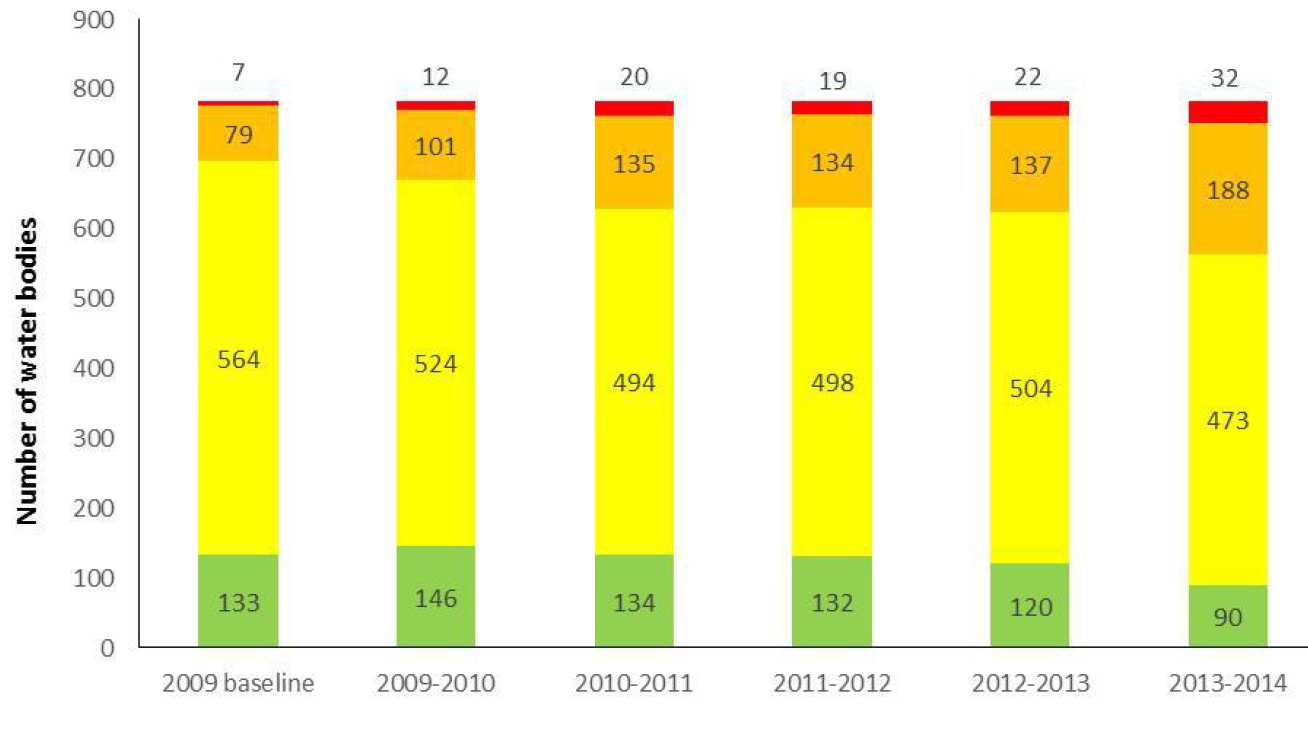
The dominance of below good status classifications and the minimal improvements over time within the Anglian RBD supports the findings of the WFD third implementation report stating the significant work to be done in the future and that the desired good status objective for the majority of water bodies will not be achieved by the start of the second planning cycle as initially intended (European Commission, 2012). Under Article 11 (7) of the WFD which states that PoMs outlined within the 2009 RBMP shall be made operational twelve years after the enforcement of the WFD (Council Directive 2000/60/EC) indicates the level of investment and commitment in managing pressures and improving the state of waters within the Anglian RBD. However, despite the level of management carried out within the district, the analyses of the WFD classifications demonstrated these limited improvements providing insights on the overall effectiveness of the current WFD implementation. This comes back to the limitations often associated with the current approach taken in regards to development of PoMs, whereby the focus on managing non-compliant elements could be deemed misleading.
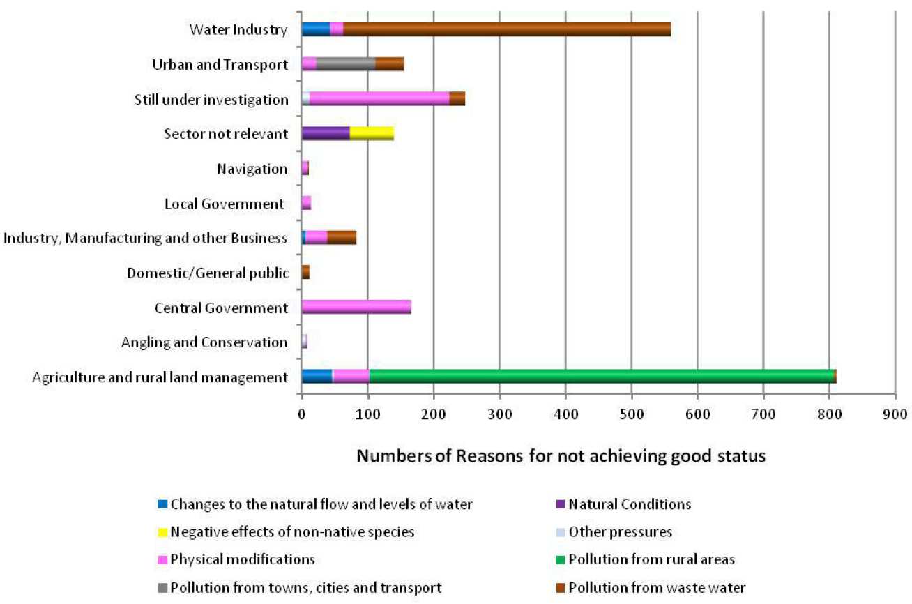
The Environment Agency (2014a) identified key management issues that are preventing the achievement of good status within the Anglian region (see Figure A6). Three management pressures were identified, namely physical modifications (affecting 51% of water bodies), pollution from wastewater (affecting 56% of water bodies) and pollution from rural areas (affecting 61% of water bodies) that were most dominant in causing failures within water bodies (Environment Agency, 2014a). The two sectors identified as contributing the most were the water industry and agriculture/land management. Despite existing collaborative schemes between these two sectors, the compliance focused management that governs the current implementation of the WFD within the region far outweighs the opportunities for a holistic and systems understanding towards management especially considering that management tend to be based on monitoring compliance to environmental quality standards with little considerations of stressor interactions.
In essence, the regional classification changes shown in Figure A6 indicate a degree of deterioration, possibly reflecting the potential limitations of the current WFD implementation. However, it is difficult to directly link changes in status to PoMs due to the response rate of the receiving environment. Biological elements can take many years to recover, and pollutants can be released back in to the water column from sediments even after the external inputs have ceased. The time lag between measures and improvements in water bodies will be site specific and depend upon the pressures present.
Nonetheless, whether or not these favourable responses are only to be seen in the long-term, this does not justify why overall deterioration of water body classifications within the region exists. One interpretation could be that the current implementation of the WFD within the Anglian region may that there are still significant challenges to be overcome. However, these regional classifications tend to hide important information including the changes in catchment and water body level emphasising on those structural parameters that are causing problem. It is important to undertake assessments at such level not only to further investigate the limitations of the current WFD implementation but also highlight specific areas within the catchment where future management could be prioritised.
For staff
If you are a new CEP staff member and would like to be included on the research webpages, or would like to amend your existing details, please submit this form (login required- only works for members of CEP).