Using seabed bathymetry to image inversion structures in the offshore Wessex Basin
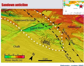
We used a compilation of single-beam bathymetry to unravel the development of a Mesozoic basin on the UK continental shelf. The basin lies just south of the Isle of Wight – a classic area of English geology – where spectacular cliff exposures of near-vertical rocks are evidence of the same compressive forces that formed the Alps. The offshore structures are seen in remarkable clarity as strong tides in the English Channel sweep away loose sediments that would otherwise mask them (Fig.1). The new data shows folding and faulting of the rock layers with unprecedented detail. The images are best where the geological layers are steeply dipping, and so compliments the traditional seismic method of determining off-shore structure. An accurate map of the bedrock geology can therefore be produced (fig.2).The work shows that as the basin was squeezed during the Alpine compression, soft, thinly bedded rocks were extruded out towards the sides of the basin, whereas stronger, thicker bedded rocks were folded into more open structures. The work therefore emphasizes the importance of the mechanical properties of the basin fill in controlling its later development.

Publications
Collier, J.S., S. Gupta, G. Potter, A. Palmer-Felgate (2006). "Using seabed bathymetry to identify inversion stuctures on the English Channel shelf", Geology, Vol. 34, 1001-1004. PDF
Further high-quality images can be downloaded from the VSA website
Acknowledgements
UK Hydrographic Office (UKHO) and the Maritime Coastguard Agency (MCA)
Bathymetry data collected by the MCA and archived by the UKHO was originally sourced for civil safety at sea.
Jebco Seismic UK LTD and its current owner IHS Energy
UKOGL