[Satellite image of four tropical cyclones across the Pacific Ocean on 1 September 2015 (c) NASA]

Newsflash

Hurricane Beryl was a Category 4 storm that made landfall near Jamaica in July 2023. IRIS estimates that, at landfall, Hurricane Beryl was a once-in-35-year event. For pre-industrial conditions before substantial greenhouse emissions and warming this event would have been a once in-60-year event. Find the analysis here

Newsflash

Typhoon Gaemi was a destructive Category 4 West Pacific typhoon. It rapidly intensified before reaching Taiwan in a first approach. The intensity of a Gaemi type event, at the first approach, was increased by about 4 m/s or 7%.  This type of event near Taiwan has changed from an event expected on average about once every 4 years to once every 3 years. Typhoons reaching Taiwan like Gaemi have become about 50% more likely due to human-caused climate change. Find the analysis here.

Join IRIS

The DreamLab app is available on Play Store and APK for Android, and the App Store for iOS.

Imperial Community Magazine

Learn more about this initiative, including its background, methods, results and outcomes in Imperial Community Magazine's coverage: Harnessing the winds of change

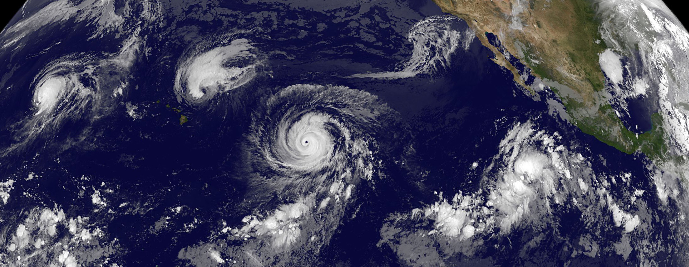
Tropical cyclones, also known as hurricanes and typhoons, are one of the deadliest and most damaging natural hazards. 

Fuelled by warm air and seas, tropical cyclones are large storm systems that form in the tropical latitudes. 

Nearly a billion people live in places that are impacted by tropical cyclones. Since 2000, tropical cyclones have caused more than US$2.4 trillion in damages globally. Tropical cyclones can be particularly devastating for developing countries that have less economic means to recover and rebuild. 

As the climate warms, the most powerful tropical cyclones are expected to become more intense and more likely.

To build resilience and reduce potential damages, communities need to understand how often tropical cyclones are expected to occur.

However, understanding the changing risk of tropical cyclones with climate change is difficult due to a scarcity of data. Globally, only about six very damaging tropical cyclones make landfall every year, and many countries only have less than 40 years of high-quality weather data on tropical cyclones. 

The Imperial College Storm Model

The Imperial College Storm Model (IRIS) is an innovative project that helps scientists and the public understand the likelihood of a damaging tropical cyclone.

IRIS is powered by Dreamlab, an app that uses idle, charging smart phones to create a virtual supercomputer. Anyone with a smart phone and an internet connection can download and run the app, to help power IRIS. All of the data is freely available and will be updated frequently as more model user data is received.

How it works

To overcome the scarcity of real-world data, the IRIS model has created a database of millions of synthetic tropical cyclone tracks. 

These tracks map the tropical cyclone from formation to landfall and describe how powerful the winds are at each stage of the tropical cyclone’s life. 

Crucially, the model can determine the likelihood of a given tropical cyclone wind speed impacting any location in the world. For example, in today’s climate, a Category 5 hurricane making landfall in Florida with winds above 252 km/h can be expected to occur on average only about once every 60 years, while a Category 3 hurricane making landfall in Florida with winds above 178m/h are much more common, expected to occur about once every 30 years, according to IRIS.  

This method is described in greater detail in a paper published in Nature.

Attribution with IRIS

While several attribution studies have quantified the influence of climate change on tropical cyclone rainfall, very few have investigated tropical cyclone winds because most climate models can not accurately simulate strong storms. IRIS’s innovative methodology provides a solution to this problem by modelling synthetic tropical cyclones and applying the concept of potential intensity.

Potential intensity is a powerful metric that predicts the maximum possible wind speed. It is calculated from the sea surface temperature, air moisture, and air temperature. It will vary by location and month.

To understand the potential intensity of these tropical cyclones in a counterfactual, preindustrial climate without human-caused warming, recent decadal trends in potential intensity are extrapolated backwards. This backwards shift is only small as the global mean temperature in the 1980s, the earliest weather data is very high-quality, was only 0.4°C warmer than pre-industrial climate, compared to 1.2°C today. 

The difference in the storm intensity and likelihood of this storm intensity between the counterfactual climate and today’s climate can be attributed to climate change. The model uses historical tracks to simulate realistic landfall locations. 

For example, an IRIS attribution analysis on Typhoon Haiyan, a Category 5 cyclone that hit the Philippines in 2013, found the typhoon was extremely unlikely without climate change. 

According to IRIS, in a cooler climate without human-caused warming, typhoons as powerful as Haiyan are expected to hit the Philippines about once every 9,300 years, but in the climate with 0.8°C of warming, similar typhoons are expected to occur about once every 130 years. 

The intensity changes predicted by IRIS is similar to full physics numerical model studies of Haiyan such as Takayabu et al., 2015 and Delfino et al., 2023, and will be described in a forthcoming paper submitted to Atmospheric Science Letters. A preprint is available here: Climate Change Attribution of Typhoon Haiyan with the IRIS model (PDF).  

Results (excluding analysis of Hurricane Beryl) 

[Please enable cookies to see the map below]

Map

Figure 1. Map shows the return period of cyclones making landfall simulated during the entire project (October 2022-now). Click the icon for selected regions of interest. The map also shows Category 5 (their lifetime maximum) synthetic cyclones tracks (paths) simulated recently.


Figure 2. Illustration of the return period to understand the pop-ups in Figure1. In this example the dashed line shows a 100-year event would correspond to a Category 5 storm.


Figure 3. Number of model landfall damaging cyclones (Category 3, 4, 5) simulated recently by IRIS. We are generating over 100,000 storms every month.


Visualise the data

We now have some first results where all can examine the data. You can find them on the two portals below that are used for risk management, climate change adaptation and disaster risk reduction. 

G-SRAT and OS-C (under wind hazard).

Questions?

For more discussion on the project, join the DreamLab forum on Reddit.

"It's easy to feel overwhelmed by the climate crisis, but with mass accessible projects like these, everyone has a chance to participate & help to bring scientific insights." - Paul, from Germany
Professor Ralf Toumi introduces the IRIS project

Next steps

How much more likely are more damaging storms under climate change?

The impact of climate change on tropical cyclones is highly uncertain and one the greatest challenges. We will deploy IRIS in future DreamLab projects to assess climate change impact.

For more information, please contact us at grantham-communications@imperial.ac.uk.

Source: Sparks, N., Toumi, R. The Imperial College Storm Model (IRIS) Dataset. Sci Data 11, 424 (2024). https://doi.org/10.1038/s41597-024-03250-y